


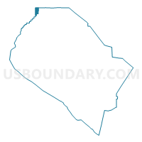
Voting District 42376, Orange County, California
About
Outline

Summary
| Unique Area Identifier | 536414 |
| Name | Voting District 42376 |
| County | Orange County |
| State | California |
| Area (square miles) | 1.97 |
| Land Area (square miles) | 1.97 |
| Water Area (square miles) | 0.00 |
| % of Land Area | 100.00 |
| % of Water Area | 0.00 |
| Latitude of the Internal Point | 33.92926700 |
| Longtitude of the Internal Point | -117.96858770 |
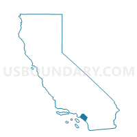
Maps

Graphs
Select a template below for downloading or customizing gragh for Voting District 42376, Orange County, California


Neighbors
Neighoring Voting District (by Name) Neighboring Voting District on the Map
- Voting District 42211, Orange County, CA
- Voting District 42212, Orange County, CA
- Voting District 42216, Orange County, CA
- Voting District 42221, Orange County, CA
- Voting District 42226, Orange County, CA
- Voting District 42231, Orange County, CA
- Voting District 42236, Orange County, CA
- Voting District 42381, Orange County, CA
- Voting District 43453, Los Angeles County, CA
- Voting District 43939, Los Angeles County, CA
- Voting District 43942, Los Angeles County, CA
- Voting District 44272, Los Angeles County, CA
- Voting District 44341, Los Angeles County, CA
- Voting District 44344, Los Angeles County, CA
- Voting District 44347, Los Angeles County, CA
- Voting District 44500, Los Angeles County, CA
Top 10 Neighboring County Subdivision (by Population) Neighboring County Subdivision on the Map
- Anaheim-Santa Ana-Garden Grove CCD, Orange County, CA (1,648,519)
- Whittier CCD, Los Angeles County, CA (316,911)
Top 10 Neighboring Place (by Population) Neighboring Place on the Map
- Whittier city, CA (85,331)
- La Habra city, CA (60,239)
- La Mirada city, CA (48,527)
- East La Mirada CDP, CA (9,757)
- La Habra Heights city, CA (5,325)
Top 10 Neighboring Elementary School District (by Population) Neighboring Elementary School District on the Map
- Fullerton Elementary School District, CA (118,074)
- East Whittier City Elementary School District, CA (73,117)
- La Habra City Elementary School District, CA (49,429)
- Lowell Joint Elementary School District, CA (34,371)
Top 10 Neighboring Secondary School District (by Population) Neighboring Secondary School District on the Map
- Fullerton Joint Union High School District, CA (249,728)
- Whittier Union High School District, CA (218,195)
Top 10 Neighboring Unified School District (by Population) Neighboring Unified School District on the Map
Top 10 Neighboring State Legislative District Lower Chamber (by Population) Neighboring State Legislative District Lower Chamber on the Map
Top 10 Neighboring State Legislative District Upper Chamber (by Population) Neighboring State Legislative District Upper Chamber on the Map
Top 10 Neighboring 111th Congressional District (by Population) Neighboring 111th Congressional District on the Map
Top 10 Neighboring Census Tract (by Population) Neighboring Census Tract on the Map
- Census Tract 5037.03, Los Angeles County, CA (7,876)
- Census Tract 17.07, Orange County, CA (7,482)
- Census Tract 5034.01, Los Angeles County, CA (6,529)
- Census Tract 13.01, Orange County, CA (6,423)
- Census Tract 5002.01, Los Angeles County, CA (6,179)
- Census Tract 12.01, Orange County, CA (5,505)
- Census Tract 5037.02, Los Angeles County, CA (5,040)
- Census Tract 11.01, Orange County, CA (4,523)
- Census Tract 11.03, Orange County, CA (4,489)
- Census Tract 5001, Los Angeles County, CA (3,540)